
High winds of up to 50mph are set to hit the south coast today and tomorrow.
European Storm Forecast Experiment issued a ‘severe’ warning for a tornado, to which the MetOffice gave a conflicting response.
Oliver Claydon, lead press officer at the MetOffice, said: “There is a small chance of an isolated tornado today as a squally front moves eastward.”
This is primarily for Wales and southern parts of England. Mr Claydon added: “The chance of in any one location is very low.”
Mr Claydon clarified that there are around 30 tornadoes reported a year in the UK.
He said: “Most of them are typically small and short-lived but can cause structural damage if they pass over built-up areas.”
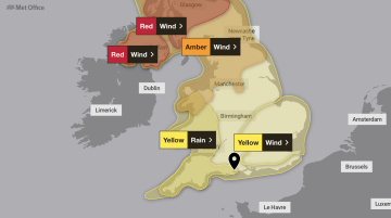
There is a yellow weather warning in place for wind until 6pm today.
Mr Claydon said: “Most areas will just experience a period of heavy rain, gusty winds, perhaps with some hail and thunder in places.”
Storm Éowyn is expected to clear into the North Sea during the afternoon.
 Weymouth winger departs with immediate effect